
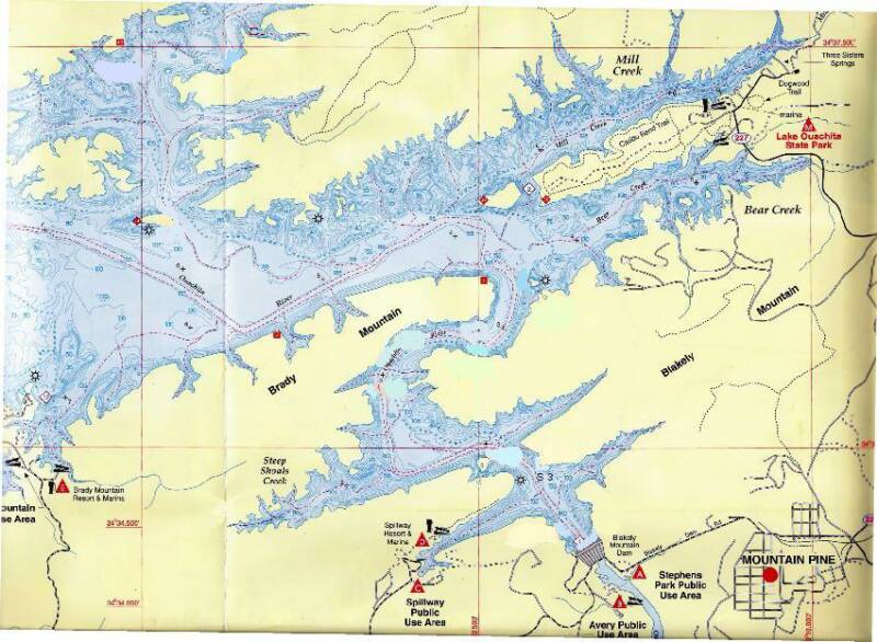
This section of the lake is easily accessible from the Spillway and Ouachita State Park Boat Launches
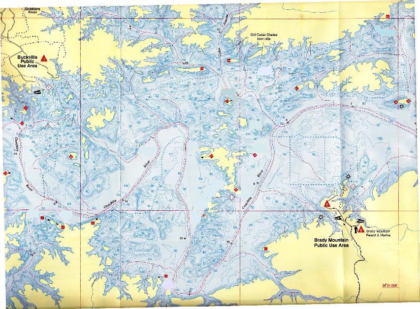
This section of the lake is easily accessible from The Brady Mountain Boat Launch
This section of the lake is easily accessible from The Crystal Springs Boat Launch
This section of the lake is easily accessible from the Mountain Harbor Boat Launch
For the M dive sites I think Mt. Harbor is the best launch site.
Site M1 Wall 26 UTM GRD Rt 046374 Up 382853Lon. & Lat. North 34o 35' 980" West 93 o 23' 726" This site is to large to do in one dive you need to do two here. Don’t look for the 26 marker here it is on the island just not at the site. This was a fun dive with a nice wall. There was a very deep wall and it had a lot of veins of quarts in it making it look very interesting. Some unique looking rocks but they were deep, in the sixty foot range. Also saw some big catfish in the neighborhood of 20 lbs or so. This is a redo dive. I have done it three times and will do it more.
Site M 2 Hamburger Island UTM GRD Rt 0463000 Up 3828740Lon. & Lat. North 34 o 36' 095" West 93 o 24' 211" Hamburger island has one fairly nice drop off on the south side but not very long or deep, if you are there you may as well look, it is interesting.
Site M 3 Red Bluff Cavern UTM GRD Rt 0463840 Up 3828590Lon. & Lat. North 34 o 36' 016" West 93 o 23' 661" Now this was a fun site. I stumbled into it at the end of a dive and had to do another dive just to get a good look and I am very glad I did another dive. Just find the small but tall Red Bluff that is in between two slate rock cliffs, go out about twenty yards and you are there, in fact that is where I dropped my anchor and that is how I found it looking for the boat. At about 50 feet you will find a very large cavern that goes down to about 73 feet. It has a lot of large veins of quarts in it and the ones in the ceiling are very clear as silt doesn’t settle on the ceiling just the walls and flour. The vis this day was just horrible, however this is more than worth the look even if it is deep . Bring your light!
Site M 4 Island marker 26 UTM GRD Rt 0464050 Up 3828740Lon.& Lat. North 34 o 57' 684" West 92 o 24' 739" This site really in front of marker 26 and to the west along the shore line. Once again very bad vis and in defense there has been a lot of boat traffic , a holiday and a lot rain. Ok here we go. Some very nice Big rock formations that run from about twenty to 50 feet. I would like to do this again on a better vis day.
Site M 5 Buckville Heel UTM GRD Rt 0464180 Up 3829760Lon. & Lat. North 34 o 57' 684' West 92 o 24' 739" Gentle slope, mud bottom, no trees or big rocks. Pretty open dive. The Visibility should be better but it had been raining for a couple of days when I was there and boat traffic was congested at best
Site M 6 Plain Jane 27
UTM GRD Rt 0465360 Up 3828830Lon. & Lat. North 34 o 36' 149" West 93 o 22' 667" Very clean bottom. Nothing there at all, just open diving. Today vis was bad but that is not always the case I am sure.
Site M 7 Middle of the chain
UTM GRD Rt 0465050 Up 38 27480Lon. & Lat. North 34 o 35' 418" West 93 o 22' 866" Not much to look at. Depth with a gentle slope, no trees or rocks. Pretty open dive.Look for good vis if it has not been raining.
Site M 8 Dogs Head east UTM GRD Rt 0464910 Up 3826260Lon. & Lat. North 34 o 34' 758" West 93 o 22' 955" From entry I went north east following the shore. Vis is OK, not many trees at all. Some nice rock formations with good size rocks but not as many as I would like. Coming back at 30 feet, the same.
Site M 9 Dogs Head West UTM GRD Rt 0464910 Up 3826260Lon. & Lat. North 34 o 34' 758" West 93 o 22' 955" From entry I went to 50+ feet and took a south- westerly heading following the contours next to shore. Vis is OK at that level, not many trees at all. A couple of good size rocks but nothing to brag about. Coming back at 30 feet about the same. At 25 feet I saw a 12-18 lb blue catfish. At 15-12 feet some bream and a couple of small bass. The bottom was mostly a gentle slope. There is a rope hanging in a tree above the water to swing from if you have time to kill in between dives. Close to the swinging rope is where I saw the Cat.
Site M10 Flat Rock Slide
UTM GRD Rt 0463720 Up 3826280
Lon & Lat North 34 o 34' 766" West 93 o 23' 733"
This was a different type dive to say the least. I saw sveral large pan fish, Bream and perch ant the like not sure what kind they were as the vis was not very good at all. I need to go back again when the water is not so rugh. It is the kind of dive site that gets bad vis in a hurry from waves hitting the land. it is a steep cliff with a nice big flat rock. Worth doing but only if the water is calm. Some people may call this a wall but I say it is a cliff but nice.
Ocean Extreme Dive Shop. Full service Dive Shop. Scuba Air. Located at Mountain Harbor next to the boat launch Open Tuesday - Sunday 9 til 5 Phone (870) 867 1223 The main store is in North Little Rock and the number there is (501) 812 0006 Air is $5.00
Site L.O. 1 Zebra Rock UTM Grd Rt 0481051 Up 3829700Lon. & Lat. 34 o 36' 644" West 93 o 12' 401" Some interesting boulders, with veins of white rock running through them, to play around pretty neat looking and mostly less than 30 feet. Deeper than that was clear and not a lot of trees. There was a Bald Eagle that flew over while I was in the water, may have a nest near by.
Site L.O. 2 Crystal Island South side UTM Grd Rt 0481096 Up 3829431Lon. 34 o 36' 499" West 93 o 12' 371" Some interesting ledges about 10-12 feet wide that run all along the south side at different depths around 40, 50 and 60 feet. This is a clean looking dive with out a lot of trees and only a few large rock but still a nice site.
Site L.O. 3 Crawdad Island UTM GRD Rt 0481460 Up 3828680Lon. & Lat. North 34 o 36' 093" West 93 o 12' 132" This site is a lot of fun, has a lot of depth and from what I saw, and heard from other divers, it almost always has good Vis. On this day the vis was not so good at 25 feet and up, but great below that. Some big rocks to play around and all in all a good dive.
Site LO 4 Boulder Playground UTM GRD Rt 0480887 Up 3827736Lon. Lat. North 34 o 35' 581" West 93 o 12' 505" Very nice site with lots of big rocks to play around that go from the surface to about fifty feet I did not go deeper than that I will and update then. Vis was very good.
For all the “S” sites I think that the Spillway Marina is the best launch site.
Site S1 Dam site UTM GRD Rt 0482100 Up 3825560Lon. & Lat. North 34 o 34' 405" West 93 o 11' 709" This site is always good even if the Vis is bad everywhere. This is a fun site I have done several times and will do again. When I have had a day with bad to horrible vis all day I will come here at the end of the day to give me that pick me up with good vis. It has some play things at the 40 foot level. Things like small boats, Golf cart, and that kind of stuff. It also has a lot of fish almost all the time. It is a easy dive that anyone can do and have fun. It has a gentle slope that goes down to about 180 feet or so. if you drive there it is easy walking but a lot of steps to get from the top of the Dam to the bottom I mean a lot but they are good concrete steps well maintained. I took a boat several times and drove there twice. I will go again it is a fun dive all the time. An excellent place to try out night diving. Some dive shops hold classes here.
Site S 2 Intake Bank UTM Rt 0481726 Rt 3825748Lon. Lat. North 34 o 34' 507" West 93 o 11' 954" This site has a steep slope but no wall or big rocks. It had some standing and down trees but it was a nice dive. I only went to fifty feet I will come back and go deeper then update.
Site S3 Slate Ground UTM GRD Rt 0481600 Up 3826520Lon. Lat. North 34 o 34' 924" West 93 o 12' 037" Nice dive site. Medium to steep slope. Very good visibility below 55 feet, standing trees, not many down though and fairly open. Above 55 feet no trees A lot of nice slate rocks to pick for your tank with very interesting colors and shapes. A few big rock formations. A very fun dive.
Site S 4 Easy Island UTM GRD Rt 0480900 Up 3826550Lon. & Lat. North 34 o 34' 940" West 93 o 12' 495" OK THIS IS IT FOR VISIBILITY. At 73 feet+ vis was at least 50 feet, probably more. This was the best vis I have had to date in Arkansas. From 50 feet and up no trees at all, not even downed trees. Very clean dive, not real steep at all, a few scattered rocks here and there, mostly clean and clear fun. Friendly fish, bring cheese whiz. Above 30 feet a good amount of little bream and bass, no records but nice. This is what I thought and hoped diving was going to be like.
Site S 5 Whirlpool Rock UTM GRD Rt 0479604 Up 3827292Lon. Lat. North 34 o 35' 040" West 93 o 13' 344" OK I found the rock. Yes it is impressive but If you like this you will really like M1 and M3. They are just as good in fact I liked them better. The rock bottoms out about fifty feet and goes up almost to the surface so everyone can see this one. Don’t get me wrong it is a do again site and I have done it three times.
Site S 6 Whirlpool bend UTM GRD Rt 0479680 Up 3827600Lon. &Lat. North 34o 35' 506" West 93 o 13' 295" This was an OK dive, fairly steep slope, clear to almost 60 feet, then trees, but not a lot. Some rock formations at the 25 foot level that look cool. In the mouth of the cove I was told there is a sunken fishing boat but I did not see it. Visibility was nice very nice on one day I dove it twice and will go again, the fishing was great.I hope this was, and will be, of some use to you. This is not meant to be a suggested or recommended dive site list and I take no responsibilities for anyone diving there. It is just some places I dove and what I saw when I was there. Good luck and good diving.
Site B 12 Double Trestle UTM GRD Rt 0476350 Up 3830800Lon. & Lat. North 34 o 37' 234" West 93 o 15' 479" Railroad bridge hard to find. I didn’t find them. A bunch of trees, in fact you are in a forest, but still a cool dive. I just stayed below the trees, no problem all these trees were pretty much standing, in fact I don’t recall seeing any down but there has to be one or two. It was just like walking through the woods so if trees bother you don’t waste your time. I liked it, will do it again. All in all a good dive.
Site B 13 CheckerBoard Point (Marker #48) UTM GRD Rt 0477340 Up 3829380Lon. & Lat. North 34 o 36' 467" West 93 o 14' 829" Easy Dive, good visibility. Saw a very large red belly perch, I mean bigger than my hand, closer to two hands, it looked to be about 14 oz or so and very pretty. Not afraid of me at all. A lot of fun here.
Site B 14 Rock Hunters Place (Main Land Marker 47) UTM GRD Rt 0478102 Up 3831101Lon. & Lat. North 34 o 37' 399" West 93 o 14' 333" Oh what a great deep water dive! There was no wall but plenty of depth, very good vis deep. It was a combination rock slide and cliffs but not a lot of trees which was nice, shallow was great too. Of course vis was not as good but still very good. If you have a fish tank at home come here and get your decorative rocks. A very pleasant dive no matter what your depth.
For all The “B” sites I think that Brady Mountain is the best launch site
Site B 1 Tip Of Snoopy’s Ear UTM GRD Rt 0471520 Up 3824680Lon. & Lat. North 34 o 33' 915" West 93 o 18' 628" Interesting short dive around three sides of a peninsula that is sometimes an island. A few trees, sharp slope, good vis. I liked this one and have done it twice.
Site B 2 Pac Man UTM GRD Rt 0472520 Up 3826860Lon. & Lat. North 34 o 35' 100" West 93 o 16' 192" Another clear bottom, hardly any trees or rocks. Plenty of depth. OK vis at 50+ feet, 35 and up not so good, 15 and up dangerously bad. It had been raining all weekend so you know the drill.
Site B 3 Disappearing Island UTM GRD Rt 0472740 Up 3827090 Lon. & Lat. North 34 o 35' 222" West 93 o 17' 831" This is a neat little island that is sometimes there and sometimes not, depending if the lake is up or down. When it is above water, there is not much to it about fifty feet long by 75 feet wide. The dive was very clean but not much there as far as trees or rocks to look at If you follow the contours around it be careful you don’t end up in the middle of the lake as I did. There is a lot of boat traffic around this island as it is in the middle of a very used path to and from Brady Mt. Resort. In fact I did it but I don’t think it is worth the risk of being in the high traffic area as the dive has no real eye catching scenery.
Site B 4 Coyote’s Heel (On Hotel Island)
UTM GRD Rt 0472940 Up 3827320Lon. & Lat. North 34 o-35' 346" West 93 o 17' 704" This site has a gentle slope, not much in the way of trees, rock or cliffs. Just an open dive nothing to hurt you here. Just fun clean diving.
Site B 5 Coyote’s Toe (ON Hotel Island) ( Island Marker 41) UTM Rt 0473130 Up 3827150Lon & Lat North 34 o 35' 254" West 93 o 17' 579" Good vis, open dive clean bottom with few trees and rocks. Suppose to be a chimney there and maybe a foundation of a school house but I did not see them. I had to stay shallow on this dive I will do again and do it deeper to check it out and update then. My last dive of the day and we stayed at forty feet.
Site B6 Coyote’s Paw (On Hotel Island) (Island Marker 42) UTM GRD Rt 0473400 Up 3828120Lon. & Lat. North 34 o 35' 779" West 93 o 17' 405" A very nice dive. You can pick your depth and follow that continuous around the point and only change depth when you want too. Not a lot of trees, good vis. A Fun Dive
Site B 7 HorseShoe Island UTM GRD Rt 0473760 Up 3828680Lon. & Lat. North 34 o 36' 083" West 93 o 17' 170" This site has depth and a gentle slope to it hardly any trees, big rocks or fish, but clear water at depths past 35 feet. A lot of white rocks on the island for the rock hunters and you can see some now and then on the bottom. I have seen other divers on the north and west side of this island on more than one occasion so there may be more here than I saw. May be a Sunken boat on East end I have not looked for it yet. Just reported to me wanted to pass along the info.
Site B 8 Coyote’s Eyebrow ( On Hotel Island)
UTM GRD Rt 0472270 Up 3828210Lon. & Lat. North 34 o 35' 826" West 93 o 18' 144" This is a clean open dive above 55 feet with a lot of slate rocks to play with about twenty five or thirty feet and up Below it is still a good dive and open but a few trees but they are scattered so no problem. Good vis and not much Hydrilla.
Site B 9 Triple Fun UTM GRD Rt 0470740 Up 3828160Lon. & Lat North 34 o 35' 797" West 93 o 19' 145" All three of these islands make one dive. The east side has depth but it doesn’t take long to cover them. The lake was down a little and there was only one island - they were all connected. No real trees to speak of. There were some cliffs in about the middle but you have to be at 55 feet or more to see it. No fish today.
Site B 10 Island Marker 39 UTM GRD Rt 0473070 Up 3829380Lon. & Lat. North 34 o 36' 462" West 93 o 17' 617" This is a neat shallow dive. There are rock formations with overhangs and not hardly any hydrilla so it is a clean dive with pretty good vis. There is a fairly steep slope at abut the forty five to fifty foot range. At the seventy to eighty foot range there are some trees both down and standing but still a good dive.
Site B 11 Under Water Knoll UTM Rt 0474079 Up 3830312Lon.& Lat. North 34 o 36' 966" West 93 o 16' 964" This is a good jump off spot that is a knoll about twenty feet under water. There is a road bed / rail road bed to the south and may be a trestle but I had to call this dive off for bad vis at the time but it will get better and I will do it and up date later.
Site B 12 Double Trestle UTM GRD Rt 0476350 Up 3830800Lon. & Lat. North 34 o 37' 234" West 93 o 15' 479" Railroad bridge hard to find. I didn’t find them. A bunch of trees, in fact you are in a forest, but still a cool dive. I just stayed below the trees, no problem all these trees were pretty much standing, in fact I don’t recall seeing any down but there has to be one or two. It was just like walking through the woods so if trees bother you don’t waste your time. I liked it, will do it again. All in all a good dive.
Site B 13 Black Jack Island (Marker #48) UTM GRD Rt 0477340 Up 3829380Lon. & Lat. North 34 o 36' 467" West 93 o 14' 829" Easy Dive, good visibility. Saw a very large redbelly perch, I mean bigger than my hand, closer to two hands, it looked to be about 14 oz or so and very pretty. Not afraid of me at all. A lot of fun here.
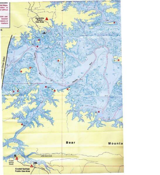
For all the “C” sites I think the best launch site is Crystal Springs
Site C1 Big Bend West UTM GRD Rt 046900 Up 3826380Lon. & lat. North 34 o 34' 830" West 93 o 20' 280" This was an OK site, no big drop off, no cliffs, no wall, a few trees, very few. A couple of fish mostly mud bottom some rocks on the bottom at shallow depth, a very nice camp site to go from to get to good dive sites. Plenty of depth just not much to see.
Site C2 Buzzard’s Chin UTM GRD Rt 0468050 Up 3826570Lon. & Lat North 34 o 34' 921" West 93 o 20' 902" FINELY! A site worth diving! You must go at least 50 feet - deeper is better - some nice drop offs, several trees both standing and laying down and some rocks to play around. Visibility this day was not so good above 35 feet, much better deeper.There is a dive shop at Brady Mountain Marina, Ouachita Dive Center, it is a full service dive shop it has Air. Hours 9-5 seven days a week. $6.00 You can call them at (501) 760 1500
Site B 1 Tip Of Snoopy’s Ear UTM GRD Rt 0471520 Up 3824680Lon. & Lat. North 34 o 33' 915" West 93 o 18' 628" Interesting short dive around three sides of a peninsula that is sometimes an island. A few trees, sharp slope, good vis. I liked this one and have done it twice.
Site B 8 Coyote’s Eyebrow UTM GRD Rt 0472270 Up 3828210Lon. & Lat. North 34 o 35' 826" West 93 o 18' 144" This is a clean open dive above 55 feet with a lot of slate rocks to play with about twenty five or thirty feet and up Below it is still a good dive and open but a few trees but they are scattered so no problem. Good vis and not much Hydrilla.
Site B 9 Triple Fun UTM GRD Rt 0470740 Up 3828160Lon. & Lat North 34 o 35' 797" West 93 o 19' 145" All three of these islands make one dive. The east side has depth but it doesn’t take long to cover them. The lake was down a little and there was only one island - they were all connected. No real trees to speak of. There were some cliffs in about the middle but you have to be at 55 feet or more to see it. No fish today.
For all the “C” sites I think the best launch site is Crystal Springs
Site C1 Big Bend West UTM GRD Rt 046900 Up 3826380Lon. & lat. North 34 o 34' 830" West 93 o 20' 280" This was an OK site, no big drop off, no cliffs, no wall, a few trees, very few. A couple of fish mostly mud bottom some rocks on the bottom at shallow depth, a very nice camp site to go from to get to good dive sites. Plenty of depth just not much to see.
Site C2 Buzzard’s Chin UTM GRD Rt 0468050 Up 3826570Lon. & Lat North 34 o 34' 921" West 93 o 20' 902" FINELY! A site worth diving! You must go at least 50 feet - deeper is better - some nice drop offs, several trees both standing and laying down and some rocks to play around. Visibility this day was not so good above 35 feet, much better deeper.
B12.
B14
B13
LO1
LO2
LO4
LO3
S6
S5
S4
S3
S2
S1
B11
B10
B9
B8
B7
B6
B5
B4
B3
B2
B1
C1
B12
B13
C2
B1
B8.
B9
C1
C2
M1
M2
M3
M4
M5
M6
M7
M8
M9
M10
4501 Fairway
North Little Rock Ar. 72116
501 812 0006
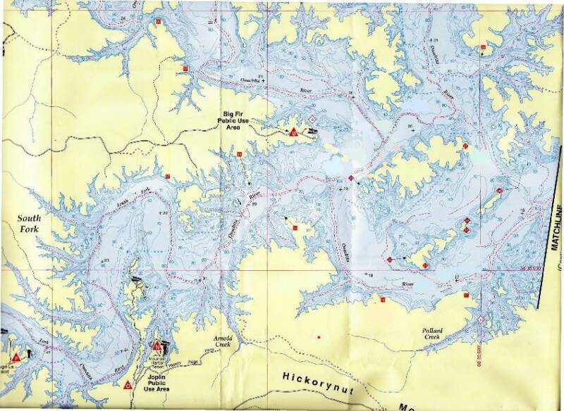
Click on a Dive Flag for
information on that site


The Datum I use on all these sites is NAD27 CONUS
Hotel Island
Crustal Island
HorseShoe Island